The picture shows the logo and the words National Park Berchtesgaden next to the small Bavarian coat of arms
  • Home
  • Nature
      • National Park
      • » Goals
      • » Zonation
      • » History
      • » Management
      • » Regulations
      • Facts
      • » Past and present
      • » Habitats
      • » Geology
      • » Flora
      • » Fauna
      • » Climate
      • Awards
      • » IUCN
      • » Europadiplom
      • » EMAS
      • » UN-Dekade
      • » Environmental education
      • » Accessibility
  • Adventure
      • Rules & Notes
      • » Safety in the high mountains
      • » Accessibility of the paths
      • » Mountain huts & pastures
      • » Behaviour rules
      • » Climbing concept
      • » Paraglider
      • Tips for on the go
      • » Barrier free
      • » Hike
      • » Bike
      • » Winter tours
      • » Outside to the toilet
      • Events
      • » Hiking program
  • Education
      • For groups
      • » General information
      • » Nursery school and elementary schools
      • » Secondary schools
      • » Adults
      • » Guided tours through the exhibition
      • Partner schools
      • » About the project
      • » Events & school projects
      • » Participating schools
      • » Newsletter
      • » Alpine School
      • » Material
  • Research
      • Projects
      • » Ongoing
      • » Finished
      • Data
      • » Working group
      • » Basic data
      • Monitoring
      • » Golden eagle
      • » Bearded vulture
      • » Climate
      • » Spring
      • » Biodiversity
      • » Forest Intensive Plot
      • Cooperations
      • » TU München
      • » Climate
      • » Ecosystems
      • » Application
  • Infopoints
      • Haus der Berge
      • » Information center
      • » Temporary exhibitions
      • » Education Centre
      • » Outdoor area
      • » Gastronomy
      • National Park
      • » Hintersee
      • » Wimbachbrücke
      • » Jenner mountain station
      • » St. Bartholomä
      • » Kühroint
      • » Engert-Holzstube
      • Other facilities
      • » Carrion ecology
      • » Observation Point
      • » Deer Feeding
      • » Suspension bridge
      • » Mobile stands
      • » Info2go
      • » Actionbound
  • Service
      • About us
      • » Contact
      • » Organization chart
      • » Contact Person
      • » Offices
      • » Cooperations
      • Getting there
      • » On foot
      • » By bus & train
      • » By car
      • Partner
      • » Partner initiative
      • » National Park Partner
      • » Biosphere Region
      • » More service links
      • Publications
      • » Programs
      • » Research reports
      • » Peer reviewed
      • Press
      • » Filming permits
      • » Press releases
      • » Press Photos
      • Media library
      • » Webcams
      • » Photos
      • » Videos
      • » App
      • General
      • » Imprint
      • » Accessibility
      • » Sign language
      • » Visual aid
      • » Font size
      • » Color contrast
      • » Contact
      • » Sitemap
      • » Netiquette
      • » FAQ
  • Startseite >> 
  • English >> 
  • Research >> 
  • Projects >> 
  • Finished

Karst water surveys

From 1997 onwards, the National Park marked karst waters on the mountain peaks of the National Park together with the Bavarian Geological Survey (GLA). The karst water marking of the Reiteralm on the Bavarian and Austrian side was financially supported by the European Union from 2003 - 2006 within the INTERREG III a program. For this purpose, the project team fed dyes into surface waters and took samples at springs and water outlets in the valley areas around the mountain ranges. Subsequently, the laboratory of the Geological Survey evaluated the water samples. The goal of the project was to identify flow paths of karst waters, explore geologic stratification in the park, and investigate the origin of waters in the valley.

The main rock types in the Berchtesgaden National Park are Dachstein limestone and Ramsaudolomite, which occur in thicknesses of up to 1200 meters. The main characteristic of this calcareous rock is its high solubility, which leads to unknown underground discharges of infiltrating water.

In the management plan 2001 of the Berchtesgaden National Park, it is listed as a research goal and measure to investigate the water occurrences in the national park and to secure the water supply of the lodging houses, alpine pastures and the surrounding communities. To implement this goal, karst hydrological studies have been carried out in the national park and a climate network has been established since 1978.

The paths of the water through the karst area have been researched in the Berchtesgaden National Park since 1987. Markers were used to clarify where the water comes from, where it flows to, whether it flows at all, how it flows and how large the volume of water is. Hydrological connections and the boundaries of the water catchment area could thus be investigated. In the Berchtesgaden National Park, the investigations have so far been carried out in the following sub-areas:


Year / Area

  • 1987/1988 Gotzenalm
  • 1990 Wimbach
  • 1997 Salzgrabenhöhle
  • 1998 Steinernes Meer
  • 1999 Endstal
  • 2001 Hochkalter/Blaueis
  • 2002 Watzmann
  • 2004 Reiteralm
  • 2005 Reiteralm(Wiederholung)
  • 2008 Wimbachgries


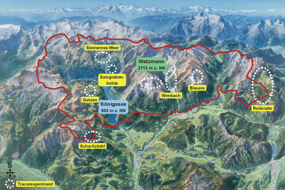
Outline map Berchtesgaden National Park


The marking tests have shown that the flow paths in the individual mountain ranges are pronounced in many directions and transport different amounts of water. The Reiteralm drains mainly into the Schwarzbachloch, a large spring in the southern edge of the mountain range. On the Hochkalter and Watzmann, flow paths have been found in all directions. The high mountain lakes of the Steinernes Meer drain via the Salzgraben cave to the southern shore of the Königssee, where numerous springs originate. The experiment at Hagengebirge showed flow paths in southern and northern directions. Marking in the terminal valley showed water spreading along many flow paths in a westerly direction along the valley outcrop. The subsurface dissolution of the rock occurs mainly at the fissures that resulted from the uplift of the Alps. Therefore, the underground flow paths result from the geological structures. Overall, therefore, a subterranean water spreading in mainly northern direction can be deduced for the area.


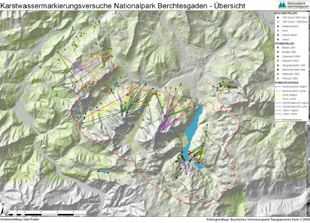
Map - karst water marking tests - overview


Download - only in german

  • KARSTHYDROLOGICAL MARKINGS in the Berchtesgaden National Park (PDF)


Contact person and project implementation:

Dr. Gabriele Leonhardt (neé Kraller), scientific evaluation (former employee)
Hans Krafft, National Park Service (former employee)

Ongoing

  • AlpsLife
  • Abandoned alpine pastures
  • Alpine pastures and climate change
  • Elevation gradients
  • Ecotones and succession
  • LiveAlpsNature
  • Forest dynamics
  • Wildlife


Finished

  • Karst hydrology
  • Spring monitoring
  • UTM

Research

Projects

  • Ongoing


    • AlpsLife
    • Abandoned alpine pastures
    • Alpine pastures and climate change
    • Elevation gradients
    • Ecotones and succession
    • LiveAlpsNature
    • Forest dynamics
    • Wildlife
  • Finished


    • Karst hydrology
    • Spring monitoring
    • UTM

Monitoring

  • Golden eagle
  • Bearded vulture
  • Climate
  • springs
  • Biodiversity
  • Forest Inventory Intensive Plot

Data

  • Working group data management
  • Basic data

Cooperations

  • TU Munich
  • Climate
  • Ecosystems
  • Application

Information Center

  • Logo Haus der Berge

  • +49 8652 979060-0
  • hausderberge@npv-bgd.bayern.de
  • Hanielstraße 7
    83471 Berchtesgaden

National Park Administration


  • +49 8652 9686-0
  • poststelle@npv-bgd.bayern.de
  • Doktorberg 6
    83471 Berchtesgaden

Service

  • FAQ

Awards

  • Logo IUCN II Logo Europadiplom Logo EMAS Logo UN-Dekade Logo Environmental Education Bavaria Logo Barrier-free Bavaria


Social Media

Visit us at Social Media


Deutsche Version

  • Deutschlands einziger Alpen-Nationalpark

Berchtesgaden National Park - Privacy | Imprint | Sitemap | Contact